Research topics


Projects
On going Projects
![]()
Period: (2023–2027)
Funder: GAČR EXPRO (Czech Science Foundation)
Keywords: Environmental Sustainability; Biodiversity; Planetary Boundaries; LCA
![]()
Period: 2024-2025
Funder: Vietnam National University, HCMC
Keywords: Urbanization; Rural urbanization; Long Xuyen Quadrangle; Remote sensing; Flood prevention dikes
![]()
Period: 2024-2025
Funder: Vietnam National University, HCMC
Keywords: Agriculture; Socioeconomics; Saline intrusion; Vietnam Mekong Delta; Flood
Past Projects
Period: 2023
Funder: CGIAR
Keywords: Climate change; Food systems; Land use; Agricultural Practices; Food crops; Mekong River
![]()
Period: 2022-2025 [resigned from 2024]
Funder: CBAS Global SDG Partnership (AIT-GISTDA collaboration)
Keywords: SDGs; Thailand; Urban; Eastern Economic Corridor
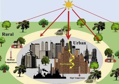
![]()
Period: 2021
Funder: KMUTT Steering Committee for Carbon Neutrality by 2040
Keywords: Remote sensing; UHIs; Green space planning; Energy consumption; InVEST
![]()
Period: 2017-2021
Funder: CTU-JICA ODA
Keywords: Remote sensing; GIS; Urban; Disasters; GHGs
![]()
Period: 2017-2018
Funder: Can Tho University
Keywords: Remote sensing; MODIS; NDVI time series; Rice